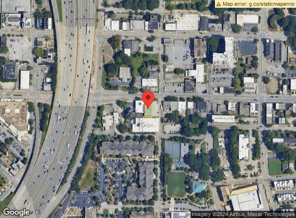
Property Record
327 Edgewood Ave Se, Atlanta, GA 30312
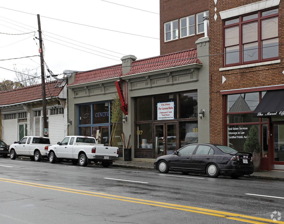
This Property Is For Sale
NEARBY LISTINGS FOR SALE OR LEASE
Property Detail
327 Edgewood Ave Se
Atlanta-Sandy Springs-Roswell, GA
Fulton
14-0045-0001-005-6
Georgia
Townhouserowhouse
0.10 AC
X
Central Atlanta
13121C0244F
Atlanta
12,158 SF
DEMOGRAPHICS near 327 Edgewood Ave Se
1 Mile
3 Mile
5 Mile
2024 Total Population
31,084
205,043
389,852
2029 Population
32,233
212,623
402,646
Pop Growth 2024-2029
+ 3.70%
+ 3.70%
+ 3.28%
Average Age
34
35
36
2024 Total Households
15,599
97,865
178,665
HH Growth 2024-2029
+ 4.30%
+ 4.00%
+ 3.53%
Median Household Inc
$75,975
$83,047
$79,709
Avg Household Size
1.60
1.80
2.00
2024 Avg HH Vehicles
1.00
1.00
1.00
Median Home Value
$445,274
$466,660
$451,032
Median Year Built
1998
1997
1988
Nearby Places
- Restaurants
- Banks
- Shops
- Fitness
- Groceries
PUBLIC TRANSPORTATION
TRANSIT/SUBWAY
Edgewood Ave (Atlanta Streetcar - Metropolitan Atlanta Rapid Transit Authority (MARTA))
DRIVE
WALK
Distance
Edgewood Ave (Atlanta Streetcar - Metropolitan Atlanta Rapid Transit Authority (MARTA))
0 min
0 min
0.0 mi
Sweet Auburn Market (Atlanta Streetcar - Metropolitan Atlanta Rapid Transit Authority (MARTA))
DRIVE
WALK
Distance
Sweet Auburn Market (Atlanta Streetcar - Metropolitan Atlanta Rapid Transit Authority (MARTA))
1 min
3 min
0.2 mi
King Historic District (Atlanta Streetcar - Metropolitan Atlanta Rapid Transit Authority (MARTA))
DRIVE
WALK
Distance
King Historic District (Atlanta Streetcar - Metropolitan Atlanta Rapid Transit Authority (MARTA))
0 min
3 min
0.2 mi
Dobbs Plaza (Atlanta Streetcar - Metropolitan Atlanta Rapid Transit Authority (MARTA))
DRIVE
WALK
Distance
Dobbs Plaza (Atlanta Streetcar - Metropolitan Atlanta Rapid Transit Authority (MARTA))
3 min
4 min
0.2 mi
King Memorial (Blue Line - Metropolitan Atlanta Rapid Transit Authority (MARTA), Green Line - Metropolitan Atlanta Rapid Transit Authority (MARTA))
DRIVE
WALK
Distance
King Memorial (Blue Line - Metropolitan Atlanta Rapid Transit Authority (MARTA), Green Line - Metropolitan Atlanta Rapid Transit Authority (MARTA))
1 min
7 min
0.4 mi
COMMUTER RAIL
Atlanta (Crescent - Amtrak)
DRIVE
WALK
Distance
Atlanta (Crescent - Amtrak)
7 min
3.9 mi
AIRPORT
Hartsfield - Jackson Atlanta International
DRIVE
WALK
Distance
Hartsfield - Jackson Atlanta International
15 min
9.7 mi
Freight Ports
Georgia Ports - Savannah
DRIVE
WALK
Distance
Georgia Ports - Savannah
278 min
249.0 mi
Nearby Properties
Address
Land Use
TOTAL SIZE
Lot Size
Zoning
Address
Land Use
TOTAL SIZE
Lot Size
Zoning
1,585,451 SF
1.97 AC
SPI2
Address
Land Use
TOTAL SIZE
Lot Size
Zoning
2,283,599 SF
12.93 AC
I1
Address
Land Use
TOTAL SIZE
Lot Size
Zoning
179.40 AC
R4
Address
Land Use
TOTAL SIZE
Lot Size
Zoning
3.16 AC
SPI1
Address
Land Use
TOTAL SIZE
Lot Size
Zoning
9 AC
C5
Address
Land Use
TOTAL SIZE
Lot Size
Zoning
1,227,912 SF
2.15 AC
SPI4
Address
Land Use
TOTAL SIZE
Lot Size
Zoning
1,905,747 SF
3.68 AC
SPI1
Address
Land Use
TOTAL SIZE
Lot Size
Zoning
10.27 AC
C5
Address
Land Use
TOTAL SIZE
Lot Size
Zoning
1,039,831 SF
0.31 AC
C4
Address
Land Use
TOTAL SIZE
Lot Size
Zoning
1,116,157 SF
1.48 AC
SPI3
Address
Land Use
TOTAL SIZE
Lot Size
Zoning
1,467,469 SF
0.06 AC
C4
Address
Land Use
TOTAL SIZE
Lot Size
Zoning
1,736,017 SF
3.63 AC
SPI2
Address
Land Use
TOTAL SIZE
Lot Size
Zoning
1,434,872 SF
1.89 AC
SPI1
Address
Land Use
TOTAL SIZE
Lot Size
Zoning
1,314,183 SF
2.61 AC
SPI1
Address
Land Use
TOTAL SIZE
Lot Size
Zoning
903,732 SF
0.34 AC
SPI1
Address
Land Use
TOTAL SIZE
Lot Size
Zoning
3,651,623 SF
28.88 AC
C3
Address
Land Use
TOTAL SIZE
Lot Size
Zoning
1,634,587 SF
3.74 AC
SPI4
Address
Land Use
TOTAL SIZE
Lot Size
Zoning
1.55 AC
SPI1
Address
Land Use
TOTAL SIZE
Lot Size
Zoning
1,553,747 SF
2 AC
SPI1
Address
Land Use
TOTAL SIZE
Lot Size
Zoning
7 AC
C3
Address
Land Use
TOTAL SIZE
Lot Size
Zoning
1,356,182 SF
2.52 AC
SPI4
Address
Land Use
TOTAL SIZE
Lot Size
Zoning
342,275 SF
0.70 AC
SPI3
Address
Land Use
TOTAL SIZE
Lot Size
Zoning
630,471 SF
0.70 AC
I2
Address
Land Use
TOTAL SIZE
Lot Size
Zoning
742,537 SF
1.56 AC
C4
Address
Land Use
TOTAL SIZE
Lot Size
Zoning
883,867 SF
2.71 AC
C1
Address
Land Use
TOTAL SIZE
Lot Size
Zoning
1,142,168 SF
2.86 AC
C4
Address
Land Use
TOTAL SIZE
Lot Size
Zoning
872,588 SF
1.77 AC
SPI4
Address
Land Use
TOTAL SIZE
Lot Size
Zoning
935,056 SF
2.35 AC
SPI3
Address
Land Use
TOTAL SIZE
Lot Size
Zoning
1,196,240 SF
1.32 AC
SPI1
Address
Land Use
TOTAL SIZE
Lot Size
Zoning
411,890 SF
0.02 AC
SPI1
The World's #1 Commercial Real Estate Marketplace
Connect with us
© 2025 CoStar Group
The information above has been obtained from sources believed reliable. While we do not doubt its accuracy we have not verified it and make no guarantee, warranty or representation about it. It is your responsibility to independently confirm its accuracy and completeness. Any projections, opinions, assumptions, or estimates used are for example only and do not represent the current or future performance of the property. The value of this transaction to you depends on tax and other factors which should be evaluated by your tax, financial, and legal advisors. You and your advisors should conduct a careful, independent investigation of the property to determine to your satisfaction the suitability of the property for your needs.